Welcome to The 49 Club new website - launched in February 2024.
This website has been re-launched in February 2025 - please click the button above to move to the latest version of The 49 Club website. We hope that you all enjoy this new user-experience.
The 49 Club use cookies to ensure that we give you the best experience on our website. If you continue to use this site we will assume that you are happy with that.
Cookies are small pieces of data recorded within your internet browser that are stored for a while by the browser for that particular website.
We only use strictly necessary cookies that are used by the website to function properly, without which the site would not work. This type of cookie does not collect any personally identifiable information about you and does not track your browsing habits.
We do not use cookies to track and monitor your online behaviour for targeted advertising, marketing research, or third-party analytics.
×
Article Number 114. This sub-section contains an article contributed by Pat Doody.
Bridgwater Bay Evolution in Maps. Click on a photo for a popup window showing larger photo.
Bridgwater Bay NNR and SSSI
Evolution in maps by Pat Doody, March 2024
This article summarises the way this section of coast, from Stolford to Fenning Island, has evolved.
Pat Doody plans further notes in this series - look out for them appearing on this website:
Note 1 deals with the Shingle ridges of Steart Peninsula, currently drafted.
Note 2 deals with Saltmarshes of the Steart Peninsular, currently drafted.
Notes 3 and 4 deal with Brean Down and Berrow dunes, in preparation.
Many thanks to Pat for producing such a fascinating article, which complements our Reunion visit to Steart Marshes NNR in June 2024.
A shorter version of this article also appears in the 2024 club Newsletter.
Below is a link for downloading the article as a PDF.
The rest of the webpage is an HTML version of the article, which may be more suitable than a PDF for viewing on internet devices with smaller screens.
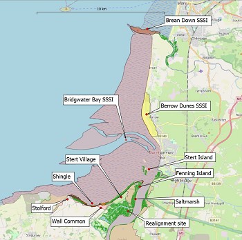
Bridgwater Bay forms part of the
Seven Estuary. At least three glacial cycles have influenced the area gouging-out
channels as the ice sheets expanded, depositing glacial till as they retreated,
with meltwater eroding the deposited sediments. Its origins lie in the infilling
of the basin with sediment during the Holocene Marine transgression, which
ended 4000 to 5,000 years ago. Bridgwater Bay NNR includes the estuary of the
River Parrett, Steart Flats and the realignment site, whilst the Site of
Special Scientific Interest extends southwards to include floodplain grazing
marsh and northwards to include Berrow Flats. At the coastal margin there are a
series of habitats, notably coastal shingle ridges and saltmarsh (Figure 01).
In 1782 Stert 'village' was connected to Stert Point by a spit
of land, a causeway (Figure 02). At that time the Point was referred to as a 'warren'.
This may have implied it was composed of sand dunes, as, in other places in
England and Wales, warrens were associated rabbit cultivation on sand dunes. The
BGS map surveyed in the 1970s shows an area of sand dunes beneath what is now
Steart village.
By 1822 this narrow neck
(causeway) had been breached and Stert Point became an island. (Figure 03).
Situated east of the Stert peninsular, the island only survived for about 70 years and on the BGS 1:63,360 scale
map of 1834 it had eroded and reappeared as Fenning Island.
This channel became
cut off by the extension of the shingle beach to form a spit around the Point.
By the next OS map (surveyed in 1902) the channel has silted up and coalesced
to form an extended area of 'Saltings'. By 1936 there were five individual recurved
ridges. Reference is also made to the "most severe erosion appears to have
taken place at the immediately east of the last groyne" (Kendall 1938 Figures
11, 12 and 13).
Change between 1902 and 2023
The Bristol Channel has one of the largest tidal ranges in
the world, second only to the Bay of Fundy in Canada. Because of this, high
tides are brief. However, when there are storms, these can effect major changes
in the coastal habitats at or near High Water. Figures 04 and 05 provide a
general picture of the overall change in the configuration of the coast. These
are based on OS maps published 1902, BGS surveys 1969-70, published 1980, BGS
1:50000 published 1980 and Google Earth 2023. See below for the map series
used.
The general impression is of an eroding coastline. Within
this there are both landward and seaward movement of habitats. In the west from
Stolford to Wall Common a series of shingle beaches moving eastwards in
response to natural longshore drift, lead to a stable foreshore over extended
periods. More intensive storm events have caused significant movement of
pebbles creating storm ridges. In places these have remobilised older ridges
and created new ones, sometimes covering stable ridges further along the coast.
Figure 04 summarises the sequence and shows that by 2023 there has been a
significant overall loss of shingle habitat. This may stem from a combination
of a reduction in availability of eroded material from the west and the rapid invasion
by Spartina anglica onto the intertidal sand and mud, following its
introduction in 1922.
Wall Common to Fenning Island
Although much narrower the shingle shore continues along the
Steart peninsular to Fenning Island (still named as an island on modern OS
maps). This has also eroded along the north shore of the Steart Peninsula.
Channels have become realigned with tides moving sand and/or mud to cover
saltmarsh. Against this background human activities have modified the natural
functioning of the coast. Coast protection, notably associated with the
construction of sea walls to protect Hinkley Power Stations, introduced species
and grazing management are the most significant.
Bridgwater Bay has evolved over thousands of years in the
Holocene. Peat deposits indicative of vegetation of the valley floor have been
dated to 8,400 BP (Before Present) (Heywood & Kidson 1982). The
post Devensian Glacial rising sea level will have submerged the surface peat
and forests, which have been dated to 7,000 BP at MLWS and 3,000 BP in front of
the storm beach at Stolford (Kidson & Heywood 1973).
The maps show how the coast is evolving as sediments move in
response to daily, monthly and yearly tidal cycles. Mudflats, sandflats and
saltmarshes are the main habitats influenced by these forces. However, in the
Severn Estuary the large tidal range is also important, especially on high
tides when storms occur. Although the timeframe is short, they can create
shingle storm beaches. These can effect major change, overwhelming existing
shingle ridges or helping to protect existing habitat, such as saltmarsh. The
closure of the channel separating Stert from Fenning Island, shows how
effective they can be as a barrier to tides and wave action.
The introduction of the invasive Spartina anglica and
its rapid expansion is a lesson in the unintended consequence of human
interference. This invasive species has had serious implications for intertidal
feeding areas for important waterfowl populations in UK estuaries. Other Human
activities interfere with the natural cycles of deposition and erosion,
including construction of sea walls. Intensive grazing has implications for the
species composition of saltmarsh vegetation and can exacerbate erosion of this
habitat.
The recent (2014) breach in the sea wall along the River
Parrett, represents a change in coastal management, where 'working with nature'
is increasing seen as a more sustainable form of sea defence, than continuing
to build and reinforce artificial barriers.
These interactions are dealt with
in more detail in separate notes on shingle and saltmarsh habitats. Berrow
Dunes and Brean Down are also included as stand along notes. They are all based
on published material including a series of OS and BGS maps, and personal
experience from occasional visits between 1980 and 2015.
- Note 1 deals with the Shingle ridges of Steart Peninsula, draft
- Note 2 deals with Saltmarshes of the Steart Peninsular, draft
- Notes 3 and 4 deal with Brean Down and Berrow dunes, in preparation
References:
British Energy Estuarine & Marine Studies (BEEMS) 2008. Hinkley Point
Intertidal Review of Biological & Physical Information. ABPmer Technical
Report Series 07/08 No. 016, EDF Energy.
Heyworth, A, and Kidson, C, 1982 Sea-level changes in southwest England
and Wales. Proc Geol Assoc93, 91-111.
Kendall, O.D., 1938. The Coast of Somerset (1). Proceedings of the
Bristol Naturalists' Society, 4/8, pp 186-208.
Kidson, C and
Heyworth, A, 1973 The Flandrian sea-level rise in the Bristol Channel. Proc
Ussher Soc2, 265-84.
Whittaker, A.
and Green, G. W. 1983. Geology of the country around Weston-super-Mare.
Memoir Geological Survey of Great Britain, Sheet 279 with parts of 263 and 295.
Long, A. J.,
Dix, J. K., Kirby, R., Lloyd Jones, D., Roberts, D.H., Croudace, I. W., Cundy,
A. B., Roberts, A. & Shennan, I., 2002. The Holocene and Recent evolution
of Bridgwater Bay and the Somerset Levels. Report to West Somerset District
Council.


 showing the extended shingle recurve with Fenning Island attached to the Stert Peninsula")